Tottori Prefecture
Tottori Prefecture
鳥取県 | |
|---|---|
| Japanese transcription(s) | |
| • Japanese | 鳥取県 |
| • Rōmaji | Tottori-ken |
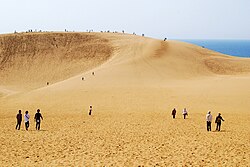
 Tottori Sand Dunes near Tottori City, a popular tourist attraction in Tottori Prefecture | |
| Anthem: Wakiagaru chikara | |
 | |
| Coordinates: 35°26′56″N 133°45′58″E / 35.449°N 133.766°E | |
| Country | Japan |
| Region | Chūgoku (San'in) |
| Island | Honshu |
| Capital | Tottori |
| Subdivisions | Districts: 5, Municipalities: 19 |
| Government | |
| • Governor | Shinji Hirai |
| Area | |
| • Total | 3,507.13 km2 (1,354.11 sq mi) |
| • Rank | 41st |
| Population (July 1, 2023) | |
| • Total | 538,525 |
| • Rank | 47th |
| • Density | 154/km2 (400/sq mi) |
| • Dialects | Inshū・Kurayoshi・West Hōki |
| GDP | |
| • Total | JP¥ 1,893 billion US$ 17.4 billion (2019) |
| ISO 3166 code | JP-31 |
| Website | www |
| Symbols | |
| Bird | Mandarin duck (Aix galericulata) |
| Flower | Nijisseiki nashi pear blossom (Pyrus pyrifolia) |
| Tree | Daisenkyaraboku (Taxus cuspidata) |
Tottori Prefecture (鳥取県, Tottori-ken) is a Japanese prefecture in the Chūgoku region of the island of Honshu.[2] The capital is the city of Tottori.[3] It is the least populous prefecture in Japan.
History[change | change source]
Before the Meiji Restoration, Tottori encompassed the old provinces of Hōki and Inaba.[4]
Geography[change | change source]
The northern coastline of Tottori faces the Sea of Japan. Its eastern border meets Hyōgo Prefecture. The southern border meets Okayama Prefecture and Hiroshima Prefecture. The western border meets Shimane Prefecture.
Cities[change | change source]
Four cities are located in Tottori Prefecture:
- Kurayoshi
- Sakaiminato
- Tottori (capital)
- Yonago
National Parks[change | change source]
National Parks are established in about 14% of the total land area of the prefecture.[5]
Shrines and Temples[change | change source]
Ubi jinjū and Shitori jinja are the chief Shinto shrines (ichinomiya) in the prefecture.[6]
Related pages[change | change source]
- Provinces of Japan
- Prefectures of Japan
- List of regions of Japan
- List of islands of Japan
- Gainare Tottori
References[change | change source]
- ↑ "2020年度国民経済計算(2015年基準・2008SNA) : 経済社会総合研究所 - 内閣府". 内閣府ホームページ (in Japanese). Retrieved 2023-05-18.
- ↑ Nussbaum, Louis-Frédéric. (2005). "Tottori Prefecture" in Japan Encyclopedia, p. 990; "Chūgoku" at p. 127.
- ↑ Nussbaum, "Tottori" at p. 990.
- ↑ Nussbaum, "Provinces and prefectures" at p. 780.
- ↑ Japan Ministry of the Environment, "General overview of area figures for Natural Parks by prefecture"; retrieved 2012-3-13.
- ↑ "Nationwide List of Ichinomiya," p. 3 Archived 2013-05-17 at the Wayback Machine; retrieved 2012-3-13.
Other websites[change | change source]
![]() Media related to Tottori prefecture at Wikimedia Commons
Media related to Tottori prefecture at Wikimedia Commons


